
|
|||||||
|
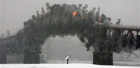
Lake Champlain Bridge between New York and VermontAfter flaws were detected in the Champlain Bridge between Crown Point, New York, and Chimney Point, Vermont, the bridge was taken down by explosive demolition. Before HNTB could build the new Lake Champlain Bridge, the debris from the demolition needed to be removed so as not to interfere with the pile driving for the new bridge. To remove the debris, it first had to be located. HNTB contracted e4sciences to map the lake bottom beneath and in the vicinity of the new bridge. The objective was to locate any obstructions to construction of the new piers and identify debris from the demolition. The secondary purpose was to map the profile of the top of rock in the areas where the new piers would be built. e4sciences performed single-beam bathymetry, side-scan sonar imaging, sub-bottom reflection seismology, and magnetic field surveys. In the course of multiple survey campaigns, e4sciences identified 51 obstructions, some of which also presented navigation hazards in the center of the channel. One of these was interpreted to be a lost spud rising more than 35ft above the channel floor. With seismic reflection data from a one-of-a-kind vented air gun and hydrophone streamer, e4sciences determined the top of rock in the area of the new span. The key focus was on the drop of the ledge in the area underneath one of the new piers. Results from new core borings corroborated the seismic interpretation. The bridge was opened on November 7, 2011. |
||||||
|
|||||||